Features
|
|
Iraya is a heavily forested stratovolcano, with an elevation the ofTemplate:Convertion asl, and a base diameter of 5,500 metres (18,000 ft).Adjacent volcanic edifice is Mt. Matarem. Mount iraya is also known as eunjung which usually erupts every year causing damage to houses, and other properties, living or not. While Mount Matarem is a volcano which doesnt erupts but only explode as a volcano. Volcanic activity. However, at present, there has not been a new activity of the said volcano, thus, opening it to the public for hiking. Its position at the northern part of Batan island gives its summit a commanding view of the northernmost parts of the country, and the ocean. This view, however, is made elusive by the perpetual cloud cover that only gives way to a full view of the mountain on rare occasions.
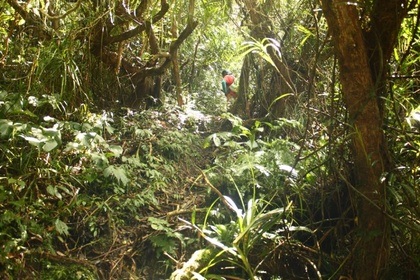
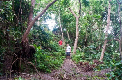
The trail to Mt. Iraya is forested and at times steep. From the jumpoff just beyond the Basco airport, there is an early, 30-minute assault, followed by a 1.5 hour trek through a dense forest, which is replete with flora and fauna, especially birds. Snakes are also said to inhabit these areas, but they are not poisonous. Beyond this forest is the "Shoulder Campsite' - an excellent viewdeck and a possible campsite. Here, trees give way to giant reeds (Miscanthus sinensis) locally known as vyawo. The final leg is the steep assault of the summit, lasting 30-45 minutes. Hold on to the reeds as you climb. At the summit, which is a ridge directing north, you will definitely feel the refreshing touch of the wind. Due to the perpetual cloud cover, moisture in the upper reaches of Iraya is high and the trails can get muddy, so prepare accordingly. Cellphone signal is present at the summit and most parts of the trail. If on an extended stay in Batanes, you may want to consult with your guide when's the best day to climb, to maximize the experience and see the fabled but elusive views of Mt. Iraya.
The trail to Mt. Iraya is forested and at times steep. From the jumpoff just beyond the Basco airport, there is an early, 30-minute assault, followed by a 1.5 hour trek through a dense forest, which is replete with flora and fauna, especially birds. Snakes are also said to inhabit these areas, but they are not poisonous. Beyond this forest is the "Shoulder Campsite' - an excellent viewdeck and a possible campsite. Here, trees give way to giant reeds (Miscanthus sinensis) locally known as vyawo. The final leg is the steep assault of the summit, lasting 30-45 minutes. Hold on to the reeds as you climb. At the summit, which is a ridge directing north, you will definitely feel the refreshing touch of the wind. Due to the perpetual cloud cover, moisture in the upper reaches of Iraya is high and the trails can get muddy, so prepare accordingly. Cellphone signal is present at the summit and most parts of the trail. If on an extended stay in Batanes, you may want to consult with your guide when's the best day to climb, to maximize the experience and see the fabled but elusive views of Mt. Iraya.
|
Due to the thick forest of Mount Iraya, and the challenging pathway in hiking to the peak, Mount Iraya invites travelers hungry and thirsty of adventurous experience. This volcano will give the thrill and excitement you will never forget. Come and experience with us the adventures you might discover along the way.
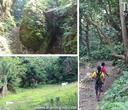
Mt. Iraya, can be climbed, but only during the height of the dry season and with the aid of a guide. The usual way starts at Basco. There are no clear trails through the dense rain forests that cover the slopes. For those who prefer not to climb to the peak, there are trails that lead part of the way up the slope and then around the volcano to its coastal side. Todate, it is a hiking haven to mountaineers and can be reached by a good 3hrs journey. The trails are considered shaggy and relatively sharp. But rewarding nonetheless. |
Email us through: [email protected] | Contact us: 123-4567 | 765-4321
